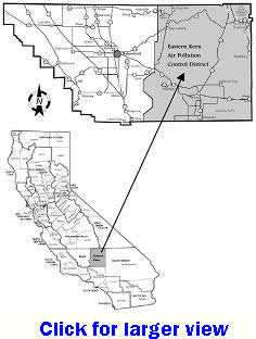
The Eastern Kern Air Pollution Control District boundary is that portion of Kern County which lies east of the line described as follows:
- Beginning at the Kern-Los Angeles County boundary and running north and east along the northwest boundary of the Rancho La Liebre Land Grant to the point of intersection with the township line common to T.9.N and T.10.N, San Bernardino Base and Meridian (SBB&M);

- then west along the township line to the range line common to T.10.N, R.16.W and T.9.N, R.17.W, SBB&M;
- then north along the range line common to R.16.W and R.17.W to the point of intersection with the Rancho El Tejon Land Grant boundary;
- then southeast, northeast, and northwest along the boundary of the Rancho El Tejon Land Grant to the northwest corner of S.3, T.11.N, R.17.W, SBB&M;
- then north to the Rancho El Tejon Land Grant boundary;
- then northwest along the Rancho El Tejon line to the southeast corner of S.34, T.32.S, R.30.E, Mount Diablo Base and Meridian (MDB&M);
- then north to the northwest corner of S.35, T.31.S, R.30.E, MDB&M;
- then northeast along the boundary of the Rancho El Tejon Land Grant to the southwest corner of S.18, T.31.S, R.31.E, MDB&M;
- then east to the southeast corner of S.13, T.31.S, R.31.E, MDB&M;
- then north along the range line common to R.31.E, and R.32.E, to the northwest corner of S.6, T.29.S, R.32.E, MDB&M;
- then east to the southwest corner of S.31, T.28.S, R.32.E, MDB&M;
- then north along the range line common to R.31.E and R.32.E, the northwest corner of S.6, T.28.S, R.32.E, MDB&M;
- then west to the southeast corner of S.36, T.27.S, R.31.E, MDB&M;
- then north along the range line common to R.31.E, and R.32.E,to the Kern - Tulare County boundary.
|
